


Refer to figure.
Determine the Ground Speed (GS) of an aircraft traveling from WINDFARM to WIMEREUX, given that it arrives at WIMEREUX at 14:43.
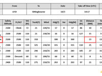
Refer to figure.
To determine the Ground Speed (GS) of the aircraft on a flight from WINDFARM to WIMEREUX, we need information such as the distance traveled and the time it took to complete the journey. This information can be obtained from the table provided.
The aircraft is overhead WINDFARM at 14:31, and the distance between WINDFARM and WIMEREUX is 23 NM.
Using the provided values, we can calculate the Ground Speed using the formula:
Ground Speed (GS) = Distance Traveled / Time Taken
To calculate the time taken, we need to subtract the time the aircraft was overhead WINDFARM (14:31) from the time it arrives at WIMEREUX (14:43), which gives us a time difference of 12 minutes.
Now, we can calculate the Ground Speed:
- Ground Speed (GS) = (23 NM / 12 minutes) x 60 = 115 kt
Your Notes (not visible to others)
This question has appeared on the real examination, you can find the related countries below.
-
France19
-
Poland8
-
Italy5
-
Spain5
-
Germany2
-
Slovakia2
-
Sweden2
-
Ireland1
-
Malta1
-
Norway1


