-
A
At approximately 800 km ahead of the surface front there is overcast cirrostratus the cloud base lowers to become a typical overcast altostratus and finally a nimbostratus. At approximately 300 km ahead of the surface front, the aircraft encounters rain which intensifies.
-
B
At approximately 500 km ahead of the surface front there is overcast cirrostratus the cloud base lowers to become a typical overcast altostratus and finally a nimbostratus. At approximately 300 km ahead of the surface front, the aircraft encounters rain which intensifies.
-
C
Flying towards the surface front, the aircraft suddenly encounters an area with a low cloud ceiling and rain, then conditions improve on the course to the West until the rain finally ceases. The cloud ceiling rises slowly, at a distance of approximately 800 km from the surface front, the sky clears.
-
D
At approximately 1000 km ahead of the surface front there is overcast cirrostratus the cloud base lowers to become a typical overcast altostratus and finally a nimbostratus. At approximately 300 km ahead of the surface front, the aircraft encounters rain which intensifies.
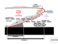
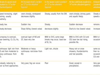
Refer to figures.
WARM FRONT. Can be defined as warm air replacing cold air.
The warm, less dense air is overtaking/displacing the cold air => warm air will ride up and over the denser cold air while advancing. The air behind the warm front is warmer and moister than the air ahead of it (when the front passes, the air becomes warmer and more humid).
- The slope of the warm air is approximately 1:100 to 1:150.
- Warm front is slower than a cold front. The front moves at right angles to itself at a speed equal to 2/3 of the geostrophic interval measured along the front.
- The warm air is mostly stable, the clouds that form are mostly stratiform. As the warm front approaches, we typically see this sequence of clouds: Cl, CS, AS, NS.
Cirrus CI: at FL250-350 as far as 600 NM (1100 km) ahead of the front.
Cirrostratus CS: at FL200-250 gradually replace the Cl (about 800 km from the surface front)
Altostratus AS: at FL150-200 as the front gets closer.
Nimbostratus NS: between 6000 - 8000 ft, approx. 150-200 NM (270- 370 km)away (in some cases up to 300 NM) until the front.
Stratus ST or Stratocumulus SC: can be encountered below the NS
Frontal FOG can sometimes be encountered 20-50 NM ahead of the frontal ground surface.
Your Notes (not visible to others)


