

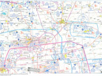
Refer to figure or VFR Chart ED-4 from Jeppesen GSPRM 2017.
An aircraft flies overhead RDG VOR (N49°02.5' E012°31.5') with magnetic track 312° outbound and reaches after 24 minutes overhead town of Nittenau (N49°12' E12°16'). What is its average ground speed on this flight leg?
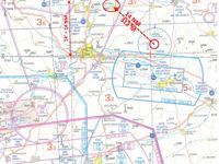
Refer to figure.
1. Locate the RDG VOR and the town of Nittenau using the given co-ordinates.
2. Determine the distance between the RDG VOR and the town of Nittenau applying one of the following methods:
- It is known that the ED-4 chart's scale is 1:500 000, as depicted in the frontal blue page of your GSPRM's ED-4 chart. So, using the appropriate scale of your plotter (SECTIONAL 1:500 000), you will find that the distance between RDG VOR and the town of Nittenau is 14 NM.
OR
- Transfer the straight line between the two points along a meridian (prefer a "clear" meridian, as free of symbols as possible). Along a meridian, it states that “1' or arc is equal to 1 NM”. Thus, since the line along the meridian is 14', then the distance is 14 NM.
3. Calculate the average groundspeed:
- Average GS = Distance / Time = (14 NM / 24) x 60 = 35 kt
Your Notes (not visible to others)
This question has appeared on the real examination, you can find the related countries below.


 Use Keyboard Shortcuts
Use your keyboard for faster navigation
