

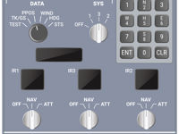
Refer to figure.
Which of the following statements is correct?
1. IRS will take 3 minutes to align at 35° latitude
2. IRS will take 10 minutes to align at 35° latitude
3. The PPOS position has to be inputted manually by the pilot
4. The PPOS position is inputted automatically without the help of the pilot
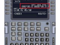

Refer to figures.
EASA learning objective states 022.05.02.01.02 states: 'Explain that the aircraft must be stationary during alignment, the aircraft position is entered during the alignment phase, and that the alignment process takes around 10 to 20 minutes at mid latitudes (longer at high latitudes).'
Alignment of Inertial Systems
Before an inertial navigation or reference system can produce any navigation information it needs to know its starting position and velocity. Alignment is always carried out while stationary so the starting velocity is always zero! Inertial systems can calculate their current latitude by sensing Earth rotation but they have no way of knowing the longitude without the pilots inputting the information. To align an IRS the pilots must input the present position (PPOS) via the flight management system (FMS) control and display unit (CDU), the FMS will give pilots the option of using the GNSS position if one is available. The IRS will compare its calculated latitude with the figure input by the pilots to confirm its alignment calculations but it has no way of checking that the longitude input is correct. To assist in avoiding pilot input errors the IRS remembers its last known position when shut down so, providing the aircraft hasn't been moved, the pilots can choose to input this position without having to manually type in the full latitude and longitude. Airport and parking gate positions are contained in th FMS navigation database to assist with PPOS insertion.
It's important to understand that the alignment times quoted in the learning objective refer to the different times taken for the alignment of first generation inertial navigation systems (INS) and second generation 'strapdown' inertial reference systems (IRS).
During alignment all inertial systems have two key phases that determine the time taken:
- Determination of the local vertical - to ensure accelerometers only measure aircraft acceleration
- Gyrocompassing - to determine the direction of True North
The time taken to complete these phases varies depending on the type of inertial system and the latitude of the aircraft.
Alignment time INS
- Before the INS can do anything the electromechanical gyros have to be spun up and reach working temperature - approx 3 mins
- Determining the local vertical involves levelling the physical platform that the accelerometers and gyros are mounted on - approx 3 mins
- Gyrocompassing involves slewing the levelled platform until the E/W gyro experiences no topple around its axis due to Earth rotation - up to 14 mins depending on latitude
Aligment time 'strapdown' IRS/ADIRS/ADIRU
- No spin up required because ring laser gyros (RLG) are instant on devices - 0 mins
- No physical platform, local vertical derived mathematically by subtracting gravity from accelerometer output - less than 1 min
- Gyrocompassing mathematically acheived by monitoring the topple sensed by the RLG's - up to 10 mins depending on latitude.
Gyrocompassing and latitude
Inertial systems measure topple due to Earth rotation to determine the direction of True North. Topple is maximum at the equator and zero at the poles so the higher the latitude the less topple for the gyros to detect and the longer it takes to gyrocompass. At very high latitudes, above about 78° N/S, it becomes impossibe to align an inertial system although you can use the system above these latitudes if already aligned.
The question asks for the time taken to align an IRS at 35° so it will take up to 10 minutes to align, a first generation INS could take several minutes longer!
1. IRS will take 3 minutes to align at 35° latitude --> INCORRECT. You might be able to get an IRS to align in 3 mins at the Equator but not at 35° N/S
2. IRS will take 10 minutes to align at 35° latitude --> CORRECT.
3. The PPOS position has to be inputted manually by the pilot --> CORRECT. Pilots input the PPOS via the FMS CDU or if the CDU is inoperative via the IRS display unit
4. The PPOS position is inputted automatically without the help of the pilot --> INCORRECT. Pilots always have to input the PPOS manually during alignment.
Note: Different manufacturers quote differing alignment times in the FCOM for their systems a Boeing 737 - 800 quotes a time of 5 to 17 mins depending on latitude and an Airbus A320 simply states that a normal alignment takes 10 mins.
'TTN' on the IRS monitor in the figure means 'total time to NAV'
Your Notes (not visible to others)
This question has appeared on the real examination, you can find the related countries below.
-
France47
-
Austro Control6
-
Germany6
-
Greece3
-
Switzerland3
-
Czech Republic2
-
Poland2
-
Romania2
-
Hungary1
-
Italy1
-
Sweden1


 Use Keyboard Shortcuts
