

An aircraft is flying under VFR by DR along a track of 312°(T), heading 310°(M) to account for the wind, and the variation of 2°W. On the first part of the leg, the pilot sees several gliders and turns to the left off the intended track to avoid them. After clearing the gliders the pilot spots a railway bridge and is able to fix the position of the aircraft. Determine the best magnetic heading to fly to the next check feature, given:
Fix position: 15 NM from the start of the leg and 2 NM off track
Distance to the next check feature: 18 NM
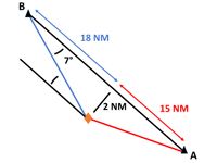
Refer to figure.
The angle at which we want to close to come back to the planned track is the closing angle (CA). The CA will depend how much further we want to rejoin the planned track.
- CA = (distance off-track/distance at which we want to rejoin track) x 60
- CA = (2 / 18) x 60
- CA = 6.67º = approx. 7º (Angle between current point and destination)
Initially, the pilot turned left off the intended track.(Red line) To get to the next check feature, he/she will have to turn right. Flying the planed track of 310º would mean he/she would be flying parallel to the intended track.(The line at below)
- The best magnetic heading to fly for the next check feature is: (Blue one)
- 310º + 7º = 317ºM
Video Explanation:
Your Notes (not visible to others)
This question has appeared on the real examination, you can find the related countries below.
-
France71
-
Spain39
-
United Kingdom34
-
Austro Control31
-
Poland26
-
Germany25
-
Greece15
-
Ireland10
-
Portugal10
-
Italy9
-
Switzerland9
-
Sweden7
-
Romania6
-
Bulgaria5
-
Czech Republic5
-
Lithuania4
-
Finland2
-
Malta2
-
Slovakia2
-
Thailand2
-
Croatia1
-
Denmark1
-
Hungary1
-
Latvia1
-
Norway1
-
Serbia1


 Use Keyboard Shortcuts
