

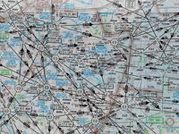
Refer to figure or to GSPRM chart E(LO) 3.
An aircraft is on a true track of 354° from LAM VOR/DME (51°39′ N 000°09′ E) at a distance of 30 DME abeam the LAM VOR/DME. Where is the aircraft located?
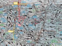
Refer to figure.
1. LOCATE THE LAM VOR/DME
We know that the LAM VOR/DME coordinates are (51°39′N 000°09′E).
- Locate the N51 parallel of latitude on the chart. Since the VOR/DME is at 51°39′N it is located further to the North by 39'. Draw a line at 51°39′N.
- Locate the 000° meridian of longitude on the chart. Since the VOR/DME is at 000°09′E it is located further to the East by 9'. Draw a line at 000°09′E.
The intersection of the two lines gives the LAM VOR/DME position.
2. DRAW A TRUE TRACK OF 354° FROM LAM VOR/DME
You need to use your plotter to measure the true track of 354°.
- Rotate the plotter’s disc, until its arrows are parallel with the chart’s meridians and indicate the True North.
- Measure an angle of 354° clockwise and draw a line.
- This line is the true track of 354°.
3. FIND THE DISTANCE OF 30 NM ON THE TRUE TRACK
You can use your plotter on the printed chart to measure the distance of 30 NM directly. However, this cannot be done on a digital chart due to different zoom settings that might apply. We know that along a meridian: 1' = 1 NM or 1° = 60 NM. Therefore, a distance of 30 NM will be equal to 0.5° which is half of the distance between the meridians N51 and N52 (yellow line on the figure). By transferring this line on the true track of 354° we can find the aircraft location, which is North of BKY VOR/DME.
Your Notes (not visible to others)
This question has appeared on the real examination, you can find the related countries below.
-
Austro Control6
-
Poland2
-
Romania2
-
Germany1
-
Hungary1
-
Latvia1


 Use Keyboard Shortcuts
