

A semi great circle on the Earth running from the North Pole to the South Pole is called a…
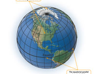
Refer to figure.
Great circle, circle represented on the surface of the earth with the same radius and center of the earth.
Equator and meridians of longitude are examples of GC. They have the following properties:
- Shortest distance between two points on the surface of the Earth happens when they are located on the arc of a great circle.
- Only one Great Circle exist between two points, unless they are situated in opposite places of the Earth.
Rhumb Line is a line represented at the surface of the earth which cuts all the Meridians at the same angle.
Is it is a line of constant direction.
The Equator and all the meridians are Great Circles and RL at the same time cause both are the shortest distance and a line of constant direction. Parallels of latitude are RL because they cut all the meridians at 90 °.
Your Notes (not visible to others)
This question has appeared on the real examination, you can find the related countries below.
-
France70
-
United Kingdom59
-
Austro Control38
-
Spain33
-
Greece11
-
Italy8
-
Ireland7
-
Poland5
-
Romania5
-
Norway4
-
Switzerland4
-
Hungary3
-
Iceland3
-
Sweden3
-
Czech Republic2
-
Germany2
-
Denmark1
-
Hong Kong1
-
Lithuania1
-
Qatar1
-
Slovakia1
-
Thailand1


