

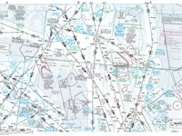
Refer to E(LO)2 Chart from Jeppesen GSPRM 2107. Given the following information, what is the aircraft’s position at the cross bearing?
TALLA (TLA) VOR (N55°30', W003°21'): Radial 215°
GLASGOW (GOW) VOR (N55°52', W004°27'): Radial 172°
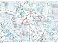
Refer to figure.
Radial is a magnetic bearing emanating from a VOR.
For this question you need a plotter to draw the radials converted into true bearings from TALLA (TLA) VOR and GLASGOW (GOW) VOR.
Firstly, find the exact position of TALLA (TLA) VOR and GLASGOW (GOW) VOR on your E(LO)2 chart, using the coordinates given and draw the radials given with the following manner:
- Center your plotter at the centre of the TALLA (TLA) VOR.
- The areas magnetic variation is 003°W.
- Rotate the plotter’s disc, until its arrows are parallel with the chart’s meridians, indicating the True North, and the course arrow indicates a True Bearing of: 215°(Radial) - 3°(variation) = 212° (Variation West - Magnetic Best).
- Draw an extended line beyond the true bearing of 212° indicated by the plotter's course arrow.
- Center your plotter at the centre of the GLASGOW (GOW) VOR.
- The areas magnetic variation is again 003°W.
- Rotate the plotter’s disc, until its arrows are parallel with the chart’s meridians, indicating the True North, and the course arrow indicates a True Bearing of: 172°(Radial) - 3°(variation) = 169° (Variation West - Magnetic Best).
- Draw an extended line beyond the true bearing of 169° indicated by the plotter's course arrow.
Your Notes (not visible to others)
This question has appeared on the real examination, you can find the related countries below.
-
France58
-
Spain29
-
Poland14
-
United Kingdom12
-
Greece11
-
Austro Control8
-
Portugal8
-
Czech Republic6
-
Ireland4
-
Finland3
-
Sweden3
-
Germany2
-
Italy2
-
Malaysia2
-
Bulgaria1
-
Denmark1
-
Hong Kong1
-
Hungary1
-
Iceland1
-
Latvia1
-
Lithuania1
-
Pakistan1
-
Romania1
-
Slovakia1
-
Thailand1


 Use Keyboard Shortcuts
Use your keyboard for faster navigation
