

-
A
Over the sea, as air masses tends to be more humid there than elsewhere leading to more intense airframe icing.
-
B
Over mountain range, as this causes upward air motion on the windward side, forcing large supercooled water droplets to rise above the freezing level.
-
C
Over flat areas, where convection is usually most intense, leading to convective clouds containing a lot of water and a greater tendency for icing.
-
D
The risk of encountering airframe icing is the same over all areas, due to the flight level being flown.
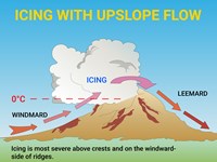
Refer to figure.
When air encounters a high ridge of terrain, it is compelled to ascend. This upward motion, especially in unstable atmospheric conditions, can give rise to the formation of Cumulus (Cu) or Cumulonimbus (Cb) clouds and potentially trigger thunderstorms, provided there is an ample amount of water vapor present. Strong winds combined with moist air can induce convective instability, leading to the development of Cumulonimbus clouds and thunderstorms.
In regions characterized by rugged topography, this uplifting process can become quite vigorous, resulting in the generation of extensive cloud cover and vertical growth due to convective instability. Moreover, this can enhance the intensity of precipitation.
The orographic lift phenomenon amplifies the concentration and size of Supercooled Large Droplets (SLD), thus flying through orographic clouds increases the risk of icing. In stable atmospheric conditions, the freezing level is positioned lower, and the severity of icing is heightened both upwind and downwind of the mountainous range.
Your Notes (not visible to others)
This question has appeared on the real examination, you can find the related countries below.
-
France24
-
Austro Control14
-
Spain7
-
United Kingdom5
-
Germany4
-
Greece2
-
Pakistan2
-
Poland2
-
Czech Republic1
-
Italy1
-
Malaysia1


 Use Keyboard Shortcuts
