

When a pilot reports a potential lightning strike, which of the following effects or actions may be associated with such an incident?
1. Localised skin damage to the aircraft structure
2. On small aeroplanes, pitot instruments may be affected
3. In modern aircraft it is generally not a concern because the aircraft is electrically bonded
4. Malfunction of the magnetic compass
5. The aircraft must be checked by an engineer after landing
6. If the crew confirms that instruments are working normally, no engineering inspection is required
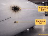
Refer to figure.
Lightning strikes can occur when an aircraft flies through regions of strong electrical charge associated with thunderstorms, typically near cumulonimbus clouds. Although aircraft are designed to conduct the electrical current safely along the outer structure, a strike can still cause structural damage or system disturbances. Therefore, a maintenance inspection is normally required after a suspected lightning strike.
- Localized skin damage to the aircraft structure → CORRECT. Lightning usually enters and exits the aircraft at attachment points such as the nose, wingtips, or tail. This can cause burn marks, pitting, or small areas of structural skin damage.
- On small aeroplanes, pitot instruments may be affected → CORRECT. Electrical discharge from a lightning strike can damage exposed probes such as pitot tubes or their heating elements, which can lead to unreliable pitot-static instrument indications.
- In modern aircraft it is generally not a concern because the aircraft is electrically bonded → INCORRECT. While electrical bonding helps conduct the lightning current along the aircraft skin (Faraday Cage effect) and protects passengers and systems, a lightning strike is always a concern. It can still cause structural damage or disrupt sensitive electronics.
- Malfunction of the magnetic compass → CORRECT. The strong electromagnetic field associated by a lightning strike can temporarily disturb magnetic instruments. This may cause erratic or unreliable compass indications during or shortly after the strike.
- The aircraft must be checked by an engineer after landing → CORRECT. After a reported or suspected lightning strike, the aircraft must normally be inspected by maintenance personnel to check for possible entry and exit points, burn marks or skin damage, bonding issues, and potential effects on aircraft systems.
- If the crew confirms that instruments are working normally, no engineering inspection is required → INCORRECT. This is false and directly contradicts statement 5. A crew check does not substitute for an engineering inspection after a lightning strike.
Related questions: No: 502649 and No: 504407
Your Notes (not visible to others)
This question has appeared on the real examination, you can find the related countries below.
-
United Kingdom7


 Use Keyboard Shortcuts
