

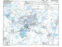
Refer to figure or Nantes chart 19-1 from Jeppesen GSPRM.
An aircraft is departing from LFRS (Nantes Atlantique) to conduct a VFR flight to the northwest. The ATC clears the aircraft to leave the control zone (CTR) via waypoint NW. Why is waypoint NW a good feature for visual identification?
-
A
NW can be identified by inserting N47°15.4' W001°41.1' into the GNSS receiver for visual identification on the moving map.
-
B
NW can be identified by using the NTS VOR/DME; it is positioned on the radial 334° at 6.5 NM.
-
C
NW is positioned on a 378 ft-tall lighted mast, which makes it easy to identify because of its large vertical extent and the illumination.
-
D
NW is positioned on the junction of two motorways, which is made unique by being the only such junction in that immediate area.
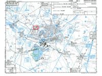
Refer to figure.
VFR reporting points around a control zone are chosen so that the pilot can identify them easily by looking outside, using distinctive natural or artificial ground features.
On the Nantes chart 19 1, the waypoint NW is located near Sautron at the junction of two motorways (in the north west area of Nantes, close to the A11 / A844 interchange). Motorway junctions are excellent VFR landmarks because they are large, geometrically distinctive from the air, unique in their immediate area, easily visible from several NM around, and permanent.
The 378 ft obstacle marked on the chart near NW is an additional reference but is not the primary visual feature that identifies the point.
NW can be identified by inserting N47°15.4' W001°41.1' into the GNSS receiver for visual identification on the moving map → INCORRECT. Entering coordinates into a GNSS receiver is an INSTRUMENT navigation technique, not a visual identification.
NW can be identified by using the NTS VOR/DME; it is positioned on the radial 334° at 6.5 NM → INCORRECT. Radial 334° at 6.5 NM from NTS VOR/DME is a RADIO navigation reference, not a visual feature.
NW is positioned on a 378 ft tall lighted mast, which makes it easy to identify because of its large vertical extent and the illumination → INCORRECT. A mast is a much less reliable VFR landmark than a motorway junction for two reasons. First, a thin vertical structure is HARDER TO IDENTIFY from far away than the large geometric shape of an interchange: at typical VFR viewing angles the mast blends easily into the background terrain, buildings or forest, and its illumination is really useful only at night. Second, a mast (especially a radio or broadcast antenna, or a temporary construction mast) may be a NON PERMANENT structure by nature: it can be DISMANTLED, MOVED or REPLACED by the operator, which would make the reference disappear while it is still shown on older charts.
NW is positioned on the junction of two motorways, which is made unique by being the only such junction in that immediate area → CORRECT. NW is located at a distinctive motorway junction in the northwest of Nantes (near the A11 / A844 interchange). Motorway junctions are excellent VFR landmarks because they are large, geometrically distinctive from the air, unique in their immediate area, permanent, and easily visible from several NM around.
Your Notes (not visible to others)
This question has appeared on the real examination, you can find the related countries below.
-
France10
-
Austro Control8
-
Italy4
-
Spain3
-
Germany2
-
Greece2
-
Sweden1
-
Switzerland1


 Use Keyboard Shortcuts
