

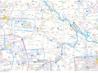
Refer to figure.
(For this question use VFR chart ED-4 from the Jeppesen GSPRM 2017).
The track between Regensburg Oberhub aerodrome (EDNR) (N49° 09', E012° 05') and Strunkovice aerodrome (LKSR) (N49° 05', E014° 05') is 092° (T). What is the magnetic track?
Refer to figure.
The two aerodromes, Regensburg Oberhub (EDNR) and Strunkovice (LKSR) are between the isogonals 2.5°E and 3.0 E°, thus the rounded variation is 3.0E°.
Applying the rhyme: “Variation East, Magnetic Least”, the magnetic track is less from the true track by 3°.
So, the Magnetic track is 092°(T) -3° = 089°(M).
Your Notes (not visible to others)
This question has appeared on the real examination, you can find the related countries below.
-
France29
-
United Kingdom25
-
Spain15
-
Germany14
-
Greece10
-
Austro Control9
-
Poland8
-
Sweden8
-
Czech Republic7
-
Denmark6
-
Ireland5
-
Norway4
-
Pakistan4
-
Portugal4
-
Hungary3
-
Latvia3
-
Switzerland3
-
Finland2
-
Belgium1
-
Bulgaria1
-
Liechtenstein1
-
Lithuania1
-
Luxembourg1
-
Malaysia1
-
Slovakia1


Use your keyboard for faster navigation
