

Which of the following correctly describes a Fixed Radius Turn (FRT)?
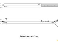
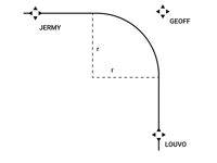
Refer to figures.
“A fly-over waypoint with a fixed radius to the next waypoint” → INCORRECT. A fly over waypoint is not required in the regulations, although it is generally how these procedures are flown. However this is not the most correct definition of a FRT.
“A constant-radius turn between two route segments (legs)” → CORRECT. This is the exact definition of a FRT.
“A turn from one waypoint directly to the next waypoint” → INCORRECT. This is a radius to fix.
“A fly-by waypoint” → INCORRECT. This is a fly-by waypoint.
ICAO PBN Manual Doc 9613
5.2.1 Fixed radius paths (FRP): The FRPs take two forms: one is the radius to fix (RF) leg type (see Figure I-A-A1-4). The RF leg is one of the leg types described that should be used when there is a requirement for a specific curved path radius in a terminal or approach procedure. The RF leg is defined by radius, arc length, and fix. RNP systems supporting this leg type provide the same ability to conform to the track-keeping accuracy during the turn as in the straight line segments.
5.2.2 The other form of the FRP is intended to be used with en-route procedures. Due to the technicalities of how the procedure data are defined, it falls upon the RNP system to create the fixed radius turn (also called a fixed radius transition or FRT) between two route segments.
5.2.3 These turns have two possible radii, 22.5 NM for high altitude routes (above FL 195) and 15 NM for low altitude routes. Using such path elements in an RNAV ATS route enables improvement in airspace usage through closely spaced parallel routes.
Your Notes (not visible to others)
This question has appeared on the real examination, you can find the related countries below.
-
Austro Control1
-
Finland1
-
Germany1
-
Greece1


 Use Keyboard Shortcuts
