

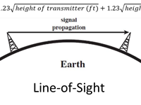
Refer to figure.
VORs transmit their signals via VHF (Very High Frequency) radio transmissions. These travel in straight lines, and will not go through solid objects such as buildings, mountains, the ocean, etc. This question mentions gaining the aerodrome weather from the VOR, which is possible as many airfield VORs have the ATIS readout on the VOR audio frequency.
We call these signals "line-of-sight", as, if the antennas can "see" each other, they can transmit between each other. Of course, that depends on the power of the transmission, as higher power transmitters allow for a greater range.
With the Earth being curved, this does pose a problem for long range transmissions between aircraft and ground stations, as the aircraft may not be within line of sight of the ground station. The ways to fix this are to get closer or go higher.
The higher the aircraft gets, the further it can "see", so that means it can communicate with radio stations further away.
The formula for the expected range of a transmission (Earth curvature limited) is:
Distance (nm) = 1.23 x sqrt( height of transmitter (ft) ) + 1.23 x sqrt( height of receiver (ft) )
If either the transmitter or receiver is at sea level (0 ft), then you can cut out one term from the equation, making it:
Distance (nm) = 1.23 x sqrt( height (ft) )
In this case, we are at FL 100 (10 000 ft), so our maximum range is;
1.23 x sqrt(10 000) = 1.23 x 100 = 123 nm
Your Notes (not visible to others)
This question has appeared on the real examination, you can find the related countries below.
-
France2
-
Austro Control1
-
Spain1


 Use Keyboard Shortcuts
