

An aircraft is flying from waypoint A (32°35'S 168°12'E) to waypoint B (32°35'S 165°48'W). Determine the great circle track (°T) on arrival at waypoint B.
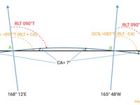
Refer to figure.
Convergency VS Conversion Angle
Convergency is the difference between two Great Circle Tracks at two separate positions, i.e. the difference in Great Circle Tracks between A and B.
- Convergency = Change of Longitude x Sin of the Mean Latitude
The difference between the great circle and the rhumb line at any point is Conversion Angle. This angle between the great circle and rhumb line tracks at either end is half the convergency.
- Conversion Angle = 1/2 Convergency
Regarding this question:
| The Latitude of both points A and B is the same (32°35'S). Point B is located East of point A (crossing Greenwich Anti-Meridian) => The Rhumb line track is, therefore, 090°. |
Both points are situated in the Southern Hemisphere, the Great Circle will be below the Rhumb Line Track. S. Hemisphere: |
Change of Longitude = 360° - (168°12'E + 165°48'W) = 26°
Convergency = Change of Longitude x sin (Lat)
Convergency = 26° x sin (32°35'S) = 14°
Conversion Angle = 14° / 2 = 7°
- Initial Track at A = Rhumb Line Track + Conversion Angle
Initial Track at A = 090° + 7° = 097° - Final Track at B = Initial Track at A - Convergency
Final Track at B = 097° - 14° = 083°
Your Notes (not visible to others)
This question has appeared on the real examination, you can find the related countries below.
-
Austro Control2
-
Poland2


 Use Keyboard Shortcuts
