

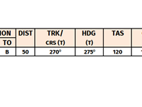
Refer to figure.
An aircraft is flying according the flight log at the Annex. After 15 minutes of flying with the planned TAS and TH the aircraft is 3 NM North of the intended track and 2.5 NM ahead of the dead reckoning position. To reach destination B from this position the TH should be:
An aircraft is flying according the flight log at the Annex. After 15 minutes of flying with the planned TAS and TH the aircraft is 3 NM North of the intended track and 2.5 NM ahead of the dead reckoning position. To reach destination B from this position the TH should be:
A ground speed of 130 kt will result in a distance after 15 minutes of 32.5 NM. 32.5 NM + 2.5 NM (ahead of DR position) = 35 NM. Drift = arc tan (3 NM / 35 NM) = 5°.
The distance from our actual position to B = 50 NM – 35 NM = 15 NM. Arc tan (3 NM / 15 NM) = 11°.
The correction angle to apply on our heading, to fly a course directly to B, is 5° + 11° = 16°. Heading to the West and drift to the North = right of course, so the correction has to be applied to the left. 275° - 16° = 259° (approximately 258°).
Your Notes (not visible to others)
This question has appeared on the real examination, you can find the related countries below.
-
Greece1
-
Italy1
-
Poland1


 Use Keyboard Shortcuts
Use your keyboard for faster navigation
