

A straight line from A (53°S 155°E) to B (53°S 170°W) is drawn on a Lambert Conformal conical chart with standard parallels at 50°S and 56°S. When passing 175°W, the True Track is…
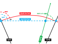
Refer to figure.
Lambert chart: Convergency = Change of longitude º x Convergence factor
Where convergence factor equals sin of Parallel of Origin.
Parallel of Origin: half way between standard parallels - in this case, standard parallels 50ºS and 56ºS => Parallel of origin is 53ºS
Convergence factor = Sin 53º = 0.7986
- Both points are on latitude 53ºS. Therefore, RLT = 090ºT
- Difference between RLT and GCT = Conversion Angle
First Step: Calculate GCT at B (from RLT at B and Conversion Angle)
At B
Conversion angle = 1/2 change of longitude x convergence factor
= 1/2 (35º) x 0.7986 = 13.98° (approx. 14°)
GCT at B = RLT - Conversion angle = 090° - 014° = 076°
Second Step: using convergency, use GCT at B to calculate GCT at 175°W
Convergency = change of longitude x convergence factor
= 5° x 0.7986 = 4°
- GCT at 175ºW > GCT at B
- At 175ºW = GCT at B + Convergency
GCT = 076° + 004° = 080°
Your Notes (not visible to others)
This question has appeared on the real examination, you can find the related countries below.
-
Austro Control2
-
United Kingdom2
-
Greece1
-
Poland1


 Use Keyboard Shortcuts
