

Refer to figures.
MONSOONS
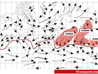
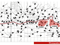
A monsoon is a seasonal change in the direction of the prevailing, or strongest, winds of a region. Monsoons lead to distinct wet and dry seasons throughout much of the tropics and are most often associated with the Indian Ocean. Weather depends very much on the track followed. There are three monsoon flows; the NE, NW & SW.
NE MONSOON:
- In winter – December, January and February, the ITCZ moves further south. Winds blow from the winter Siberian high – bringing cool and dry continental air. The NE Monsoon gives clear weather over central India, Burma and Thailand.
It also affects SE India, Sri Lanka & east coast of West Malaysia. However, in these locations, the over sea tracks pick up moisture which produces convective clouds and thunderstorms (when crossing mountain ranges).
NW MONSOON:
- When crossing the Equator, NE Monsoon backs, giving rise to the NW Monsoon which brings Convective clouds (Cu, Cb) and thunderstorms to North Australia and New Guinea.
SW MONSOON:
- In Summer – June, July and August, the ITCZ moves further north, away from the Equator. As the SE trade wind crosses the equator, it veers to SW – giving rise to the SW Monsoon. This Monsoon has a long sea track where it picks up moisture, producing heavy Cumulus and Cumulonimbus clouds with heavy thunderstorms, low cloud bases and severe turbulence (having more serious effects on flying than the NE Monsoon). The SW Monsoon affects all of India, Sri Lanka, Burma, exposed coasts of West Malaysia and West African coast (Guinea, Ghana and North Nigeria).
=> As a sum up, NE monsoons will be dry with little cloud. SW monsoon with its long sea track over the tropical oceans will produce very wet condition and convective clouds and will be warm.
Your Notes (not visible to others)
This question has appeared on the real examination, you can find the related countries below.
-
Austro Control2
-
Poland1


