

During which stage of thunderstorm development are rotor winds characterized by roll clouds most likely to occur?
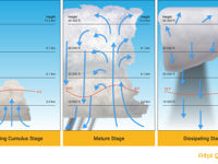
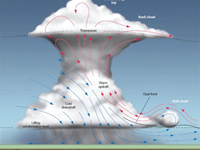
Refer to figures.
A typical airmass thunderstorm consists of three states – initial stage (cumulus stage), Mature stage and Dissipating stage.
CUMULUS STAGE/INITIAL STAGE
- Lifting action initiates the vertical movement of air
- Because of the strong updrafts (as great as 3000 ft/min), precipitation usually does not fall. Instead, the water droplets or ice crystals rise and fall within the cloud, growing larger with each cycle.
- The cloud reaches the mature stage in about 15 minutes.
=> This stage is characterized by continuous updrafts.
MATURE STAGE
- As the water droplets in the cloud grow too large to be supported by the updrafts, precipitation begins to fall. This creates a downward motion in the surrounding air and signals the beginning of this stage.
- The down-rushing air spreads outward at the surface, producing a sharp drop in temperature, a rise in pressure, strong gusty surface winds and turbulent conditions.
- Within the thunderstorm cloud, the strongest turbulence occurs in the shear between the updrafts and downdrafts (below the cloud)
- As the thunderstorm advances, a rolling, turbulent, circular shaped cloud might form at the lower leading edge of the cloud => this is called a roll cloud.
- It can last up to 30 min
=> Thunderstorms reach their greatest intensity during the mature stage (which is signaled by the beginning of precipitation at the surface).
DISSIPATING STAGE
- As the mature stage progresses, more and more air aloft is disturbed by the falling drops. Eventually the downdrafts begin to spread out within the cell – taking the place of the weakening updrafts. During this stage the upper level winds often blow the top of the cloud downwind, creating the familiar anvil shape.
=> Thunderstorms reach this stage when downdrafts become the dominant air movement within this cell.
Your Notes (not visible to others)
This question has appeared on the real examination, you can find the related countries below.
-
Austro Control4
-
Poland1
-
Portugal1


 Use Keyboard Shortcuts
Use your keyboard for faster navigation
