

On the approach, the surface temperature is given as -5 °C. The freezing level is at 3 000 ft AGL. At 4 000 ft AGL there is a solid cloud layer from which rain is falling. According to the weather briefing, the clouds are due to an inversion caused by warm air sliding up and over an inclined front.
Would you expect icing?
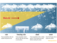
Refer to figure.
The question states that, at the surface, temperature is -5ºC. Since there is a temperature inversion in that area, temperature will increase with increasing altitude, reaching 0ºC at 3000 ft.
1. As described in the question text, the rain falls from the cloud layer at 4000 ft, where the temperature is above 0ºC.
- One of the requirements for icing to form on an aircraft is that the air temperature is below 0ºC. For that reason, icing will not be experienced between the freezing level (3000 ft) and 4000 ft.
2. It then falls through an area where the temperature is below 0ºC (from 3000 ft to the surface) => between that layer, the water droplets will become supercooled, meaning that they will remain in liquid state but have a temperature lower than 0ºC.
- The most important factor for the build-up of ice on aircraft is the freezing of supercooled drops following impact with a cold aircraft. We can, therefore, expect Freezing/Supercooled Rain, between the surface and 3000 ft, which is directly associated with the most hazardous type of ice - moderate to severe Clear Ice.
Your Notes (not visible to others)
This question has appeared on the real examination, you can find the related countries below.
-
Poland3
-
Italy2
-
Czech Republic1
-
Greece1


