

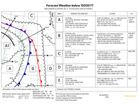
Consider a flight operating from Zone D and expected to end in Zone A, planned for the afternoon of 26th July 2017, flying at 3 000 ft AMSL. What conditions can you expect at cruising altitude?
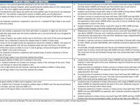
Refer to figure.
ZONE D AT 3000 FT => “Occasional scattered or broken cumulus or stratocumulus cloud with base 1500-4000ft and tops 5000-8000ft are expected, with moderate turbulence expected within this cloud.”
ZONE C AT 3000 FT => “Occasional areas of scattered or broken cumulus or stratocumulus with base 1500-4000ft and tops 5000-7000ft are expected. Moderate icing and turbulence are expected within this cloud.”
ZONE B AT 3000 FT => “A broken or overcast cumulus or stratocumulus cloud layer is forecast with a base of 1500- 3000ft, and tops 5000-8000ft, with moderate turbulence expected within this cloud.”
ZONE A AT 3000 FT => “A broken cumulus or stratocumulus layer with base 1500-2500ft and tops 6000-9000ft is expected over zone A, with moderate turbulence in this layer.”
=> We can conclude that the flight, at 3000 ft, will be mainly in clouds and moderate turbulence can be expected
Your Notes (not visible to others)
This question has appeared on the real examination, you can find the related countries below.
-
Poland5
-
United Kingdom5
-
Greece2
-
Denmark1
-
Italy1
-
Portugal1


 Use Keyboard Shortcuts
