

VHF (Very High Frequency) waves occur in which frequency range?
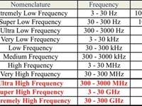
Refer to figure.
Radio Frequency (RF) is the lowest portion in the electromagnetic spectrum familiar as a medium of analogue and modern digital wireless communication system.It spreads in the range between 3 KHz and 300 GHz.
All known transmission systems works in the RF spectrum range including analogue radio, aircraft navigation, marine radio, amateur radio, TV broadcasting, mobile networks and satellite systems.
Your Notes (not visible to others)
This question has appeared on the real examination, you can find the related countries below.
-
United Kingdom8
-
Austro Control4
-
Pakistan4
-
Malaysia2
-
Portugal2
-
Ireland1


 Use Keyboard Shortcuts
Use your keyboard for faster navigation
