

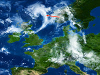
Refer to figure.
The image shows a visible satellite image of Northern Europe. The arrow points to a band of which type(s) of clouds?
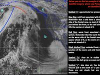
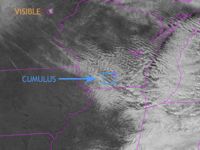
Refer to figures.
SATELLITE IMAGERY
Visual Images. Although visual photography may be easy to interpret, it suffers the disadvantage of not being available continuously, due to lack of sunlight at night. Clouds will often appear white, the land grey and the sea black. In this case, the image is in colour which is easier to read and more self-explanatory.
Infrared (IR). Infrared images have the advantage of being available for 24 hours a day and the shading of the picture will be more or less the same by day and by night. Cold (high) cloud will give a white image, lower cloud a somewhat darker one, whilst warm land will give a dark image.
Given the cumulus image above, we can see that the cloud pictured in the question is not strongly cumuliform (as it would look patchy and separated). It is therefore not cumulus, cumulonimbus, and is quite unlikely to be cirrocumulus. It is possible that it is Stratocumulus but that doesn't correspond to the shape showing or to the thickness and overall slight wispyness.
Of the options present, we believe this is most likely to be Altostratus, as the overall region appears to be the warm sector, followed by a cold front from a small, not very active, polar front depression, and the slightly wispy appearance looks like a medium to high level stratified cloud.
Your Notes (not visible to others)
This question has appeared on the real examination, you can find the related countries below.
-
Austro Control5
-
Germany3
-
Poland2
-
Portugal2
-
Azerbaijan1
-
Hong Kong1
-
Spain1
-
Sweden1


 Use Keyboard Shortcuts
