

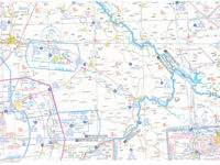
Refer to figure or VFR chart ED-4 from the Jeppesen GSPRM 2017.
What is the track and distance from FÜRSTENZELL aerodrome (EDMF, N48°31.1' E013°20.8') to Metten helipad (N48°51.56' E012°56.1')?
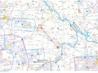
Refer to figure.
For this question you need a plotter to find the true track and measure the distance between FÜRSTENZELL aerodrome (EDMF) and Metten helipad.
Calculate Magnetic Track:
- Firstly, find the exact position of EDMF aerodrome and Metten helipad symbols on your Jeppesen ED-4 chart, using the coordinates given and draw a line with your pencil to connect these two points.
- Center your plotter at EDMF aerodrome symbol, since the question asks for the track from EDMF aerodrome.
- Align the upper section of your plotter with the line which connects the two points.
- Rotate the plotter’s disc, until its arrows are parallel with the chart’s meridians and indicate the True North.
- The aligned with the route EDMF to Metten helipad plotter’s arrow indicates the True Track 322°.
- The two points are close to the 3°E isogonal.
- Thus, following the rhyme "Variation East, Magnetic least", the Magnetic Track is: 322°T - 3°E = 319°M approximately.
Calculate Distance:
- It is known that the ED-4 chart's scale is 1:500 000, as depicted in the frontal blue page of your GSPRM's ED-4 chart.
- Using the appropriate scale of your plotter (SECTIONAL 1:500 000/NAUTICAL MILES), you will find that the distance between EDMF and Metten helipad is 26 NM.
Your Notes (not visible to others)
This question has appeared on the real examination, you can find the related countries below.
-
Austro Control16
-
Germany10
-
Greece6
-
Poland5
-
Latvia3
-
Spain3
-
Iceland2
-
Ireland2
-
Sweden2
-
Croatia1
-
Czech Republic1
-
Malta1
-
Romania1
-
Serbia1
-
Slovenia1


 Use Keyboard Shortcuts
Use your keyboard for faster navigation
