

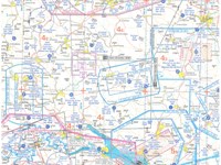
(For this question use VFR chart ED-4 from the Jeppesen GSPRM 2017). You are planning a route from Albstadt Degerfeld (EDSA) (N48°15' E009°04') to Laupheim (ETHL) (N48°13' E009°55'). What are the callsign and frequency of the Flight Information Services for this route?
-
A
Degerfeld Information 125.10 MHz and Langen Information 128.95 MHZ.
-
B
Degerfeld Information 125.10 MHz and Laupheim Information 122.10 MHz.
-
C
Langen Information 128.95 MHz, Munchen Information 126.95 MHz, and Erbach Information 118.27 MHz.
-
D
Langen Information 128.95 MHz and Munchen Information 126.95 MHz.
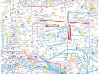
Refer to figure.
Flight Information Service or Flight Information Centre provides advice and information for the safe and efficient conduct of flights.
The provision of an FIS does not relieve the pilot-in-command of an aircraft of any responsibilities and the pilot-in-command has to make the final decision regarding any suggested alteration of his flight plan.
To figure out the FIS boundaries within which the aircraft flies from Albstadt Degerfeld (EDSA) to Laupheim (ETHL) aerodrome, advice the ED-4 VFR chart legend (back side). FIS boundaries are depicted with a grey line with a black stripe inside. Along FIS boundaries, there are FIS information boxes with their corresponding frequencies inside.
The aircraft takes off from Albstadt Degerfeld (EDSA) which is within FIS Langen Information boundaries with frequency 128.95 MHz, and flying to Laupheim (ETHL) it enters within FIS Munchen Information boundaries with frequency 126.95 MHz.
Your Notes (not visible to others)
This question has appeared on the real examination, you can find the related countries below.
-
United Kingdom41
-
Austro Control39
-
France34
-
Spain26
-
Greece15
-
Germany13
-
Czech Republic10
-
Poland10
-
Ireland9
-
Portugal7
-
Romania6
-
Italy5
-
Switzerland4
-
Denmark3
-
Finland3
-
Hungary3
-
Pakistan3
-
Sweden3
-
Luxembourg2
-
Slovakia2
-
Thailand2
-
Bulgaria1
-
Croatia1
-
Iceland1
-
Latvia1
-
Lithuania1
-
Malta1
-
Norway1
-
Serbia1


 Use Keyboard Shortcuts
