

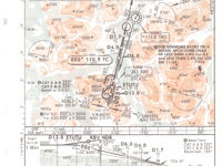
Refer to figure or Norway, Tromso Chart 11-1 from the Jeppesen GSPRM 2017.
What is the minimum visibility for an approach category A aircraft, when approaching to Tromso airport following ILS Rwy 01 approach procedure with the airport's PAPI lights inoperative?

Refer to figure.
The Chart refers to the Norway, Tromso ILS or LOC Rwy 01 approach procedure.
Immediately below the missed approach details, there is a table that gives the details of the landing minima (DA (H), RVR/Visibility) for various combinations of facilities available, for each aircraft approach category, decided by the approach IAS when crossing the threshold, as summarised in a table in GSPRM (Glossary GSP-3).
Note how lighting unserviceabilities impact on the minimum RVR:
- For approach category A, with FULL or Limited (such as PAPI light unserviceable), the minimum visibility is RVR 800 m.
- For approach category A, with Approach Lighting System (ALS) out, the minimum visibility is RVR 1500 m.
Your Notes (not visible to others)
This question has appeared on the real examination, you can find the related countries below.
-
Hong Kong3
-
Pakistan3
-
Lithuania1
-
Malaysia1


