

Which statement is true about the parallel of origin of a conformal chart?
-
A
The parallel of origin together with the standard parallel(s), are the only parallels at which the chart is conformal.
-
B
The parallel of origin is the only parallel at which the chart is conformal.
-
C
The parallel of origin is the parallel at which the scale reaches its maximum value.
-
D
The parallel of origin is the parallel at which the scale reaches its minimum value.
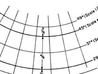
Refer to figure.
The scale on a Lambert chart is correct at the two standard parallels, because the standard parallels are the same on the globe as on the cone. The scale then decreases (contracts) between the standard parallels, reaching the minimum value at the parallel of the origin, and increases (expands) outside the parallels.
The scale on a Lambert chart is correct at the two standard parallels, because the standard parallels are the same on the globe as on the cone. The scale then decreases (contracts) between the standard parallels, reaching the minimum value at the parallel of the origin, and increases (expands) outside the parallels.
Your Notes (not visible to others)
This question has appeared on the real examination, you can find the related countries below.


 Use Keyboard Shortcuts
Use your keyboard for faster navigation
