

Which statement about the vertex of a great circle is true? In the vertex the…
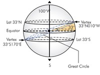
Refer to figure.
The position where the Great Circle passes closest to the pole is called Vertex. At the Vertex the direction of the Great Circle is 090° or 270°.
At the Vertex the Great Circle will achieve its highest latitude.
Your Notes (not visible to others)
This question has appeared on the real examination, you can find the related countries below.
-
Austro Control23
-
Spain23
-
France20
-
Ireland10
-
Portugal6
-
Poland5
-
Czech Republic4
-
Hong Kong3
-
Belgium2
-
Italy2
-
Norway2
-
Greece1
-
Hungary1
-
Lithuania1
-
Luxembourg1
-
Malta1
-
Romania1


 Use Keyboard Shortcuts
Use your keyboard for faster navigation
