

While flying at their assigned cruising level, the pilot of an aeroplane fitted with conventional flight controls experiences a stabiliser trim runaway to the full nose-down position. If the pilot applies full elevator deflection in the opposite direction, it will...
-
A
still result in a loss of altitude because the elevator will mechanically follow the stabiliser movement.
-
B
be possible to maintain altitude, because only the elevator nose-down effectiveness will be restricted.
-
C
still result in a loss of altitude because the elevator nose up effectiveness is restricted.
-
D
be possible to maintain altitude, because the full elevator control movement will still be available.
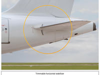
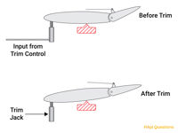
Refer to figures.
EASA learning objective 022.08.01.01.08 states:' Describe the implications for the pilot in the event of a runaway trim or significant out-of-trim state.'
On modern civil air transport aircraft pitch trim is controlled by the trimmable horizontal stabiliser (THS). This is the moveable tailplane to which the elevators are attached. The pilots control the aircraft in pitch using the elevators and the trim system moves the THS to relieve the elevator load resulting in the THS and elevator being in alignment when the aircraft is in trim. Trim can be controlled manually by the pilots using the trim wheel or trim switches but is controlled automatically by the autopilot when it is engaged.
If the trim runs away to the fully nose down position the relatively large size of the THS compared with the elevators will mean that, even with full nose up elevator applied, the aircraft will continue to descend.
still result in a loss of altitude because the elevator will mechanically follow the stabiliser movement --> INCORRECT. Pilots still have full elevator control but elevator nose up authority isn't enough to overcome a fully nose down THS.
be possible to maintain altitude, because only the elevator nose-down effectiveness will be restricted --> INCORRECT. Pilots still have full elevator control but elevator nose up authority isn't enough to overcome a fully nose down THS.
still result in a loss of altitude because the elevator nose up effectiveness is restricted --> CORRECT. Pilots still have full elevator control but elevator nose up authority isn't enough to overcome a fully nose down THS.
be possible to maintain altitude, because the full elevator control movement will still be available --> INCORRECT. Pilots still have full elevator control but elevator nose up authority isn't enough to overcome a fully nose down THS.
Your Notes (not visible to others)
This question has appeared on the real examination, you can find the related countries below.
-
United Kingdom33
-
Spain15
-
Greece7
-
Austro Control6
-
Germany6
-
Ireland5
-
Poland5
-
Norway2
-
Romania2
-
Czech Republic1
-
Latvia1
-
Thailand1


 Use Keyboard Shortcuts
