

An aircraft is executing an ILS approach. NAV 1 is tuned to the localizer (LOC) and NAV 2 is tuned to the VOR of the aerodrome. During the approach, the pilot realises that the ILS deviation shows that the aircraft is outside the localizer's outer marker. What is the indication of the VOR needle?
Refer to figure.
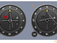
In this situation, with the ILS indicating that you are outside the localizer's outer marker, the ILS needle would be located at the outer dot (full scale deflection).
In this situation, with the ILS indicating that you are outside the localizer's outer marker, the ILS needle would be located at the outer dot (full scale deflection).
- VOR indicator: CDI needle full scale deflection represents 10° (the aircraft is 10° or more left or right of the selected course).
- ILS indicator: CDI needle full scale deflection represents 2.5° (the aircraft is 2.5° or more left or right of the centre-line).
Your Notes (not visible to others)
This question has appeared on the real examination, you can find the related countries below.
-
United Kingdom20
-
France14
-
Spain9
-
Poland3
-
Greece2
-
Bulgaria1
-
Thailand1


Use your keyboard for faster navigation
