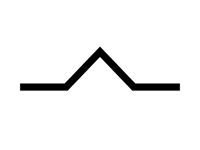
17 / 20

Light turbulence shall be always expected…

  • A

    Below cumulus clouds due to thermal convection.

  • B

    Above cumulus clouds due to thermal convection.

  • C

    Below stratiform clouds in medium layers.

  • D

    When entering inversions.

Refer to figure.
Turbulence can be caused by vertical movement of air "pockets", through either convective or mechanical means, or can be caused by a sudden change in horizontal wind speed, called windshear.

Clouds can be a good indication of the air patterns present, as stratiform clouds show stable, non-turbulent air, and cumuliform clouds show the presence of unstable, turbulent air.

Cumulus clouds are formed when air rises, and by doing so, becomes warmer than its environment, due to a high ELR (Environmental Lapse Rate, the air wants to continue to rise. Rising air cools down, and therefore becomes closer to the dewpoint (the relative humidity rises) until the dewpoint is reached, and the air becomes saturated, forming a cloud.

Therefore, the air just below a cumulus cloud is rising at quite a rate, but not perfectly evenly, due to unstable heating, meaning that there is a large difference in updraft speed from one pocket of air to the next, which causes turbulence. The base of a cumulus cloud often has more turbulence than the rest of the cloud, on average.

Downdrafts can also occur in cumulus clouds, and this would cause even greater turbulence, when happening next to an updraft.

Your Notes (not visible to others)


This question has appeared on the real examination, you can find the related countries below.

  • Austro Control
    1