

What pressure pattern is typically observed during the passage of a cold front?
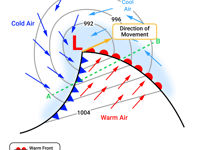
Refer to figure.
|
Changes on the Passage of a Warm Front |
||||
|
Temperature and dew point |
Visibility |
Surface Pressure |
Cloud and Precipitation |
Wind |
|
Temperature increases as cold sector air is replaced by warm sector air and dew point increases. |
Visibility steadily decreases as the front approaches, then at the front itself except frontal fog. |
Falls as area of low-pressure approaches then steadies in the warm sector. |
Cloud base lowers and cloud thickens with steadily increasing precipitation. |
Backs initially then veers at the front with a steady increase in speed. |
|
Changes on the Passage of a Cold Front |
||||
|
Temperature and dew point |
Visibility |
Surface Pressure |
Cloud and Precipitation |
Wind |
|
Temperature and dew point falls as warm sector air is replaced by cold sector air. |
Just ahead of the cold front, and as it passes, visibility will be poor, but after the cold front, visibility will improve except within the showers behind. |
Falls as front approaches, then rises as front passes. |
Embedded cumulonimbus just ahead of the front then after the front passes, cloud base rises and the clouds thin. Isolated cumulus behind the front. |
Backs just before the front, then veers sharply at the front and increases in speed. After the front has passed the wind will decrease and back. |
Your Notes (not visible to others)
This question has appeared on the real examination, you can find the related countries below.
-
Austro Control1


