

What does the HRV (High Resolution Visual) channel of satellite images show?
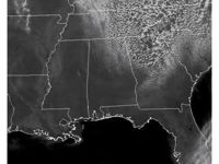
Refer to figure.
The High Resolution Visible (HRV) channel in satellite imagery operates by capturing sunlight reflected off the Earth's surface and clouds. Because it relies on visible light, it can only be used during daylight hours.
In visible satellite imagery, dark areas indicate surfaces or regions that reflect little sunlight (low albedo), such as oceans or dense forests. Bright areas, on the other hand, reflect a high amount of sunlight (high albedo), like snow-covered surfaces or thick, high-level clouds. These images are especially effective for detecting weather fronts and detailed convective cloud formations, including towering cumulus and cumulonimbus (Cb) clouds.
Limitations of HRV imagery:
- Cloud-top temperatures can't be determined (this requires infrared data).
- Rainfall or precipitation intensity isn’t directly visible (best assessed with radar or inferred from IR/microwave imagery).
- Pressure systems and forecasts are not derived from satellite images, which only capture current conditions.
Your Notes (not visible to others)
This question has appeared on the real examination, you can find the related countries below.
-
Austro Control1


 Use Keyboard Shortcuts
