

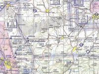
Refer to figure.
A Pilot is planning a VFR flight from Salzburg (LOWS) to Linz (LOWL). If the variation is 003°E, and the aircraft flies a direct track with a groundspeed of 120 kts, what is the flight time?
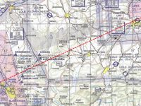
Refer to figure.
Firstly, locate the two airports and draw a straight line (direct track) connecting them.
For the chart given, the scale is not known, thus, a plotter cannot be used to determine the distance. In the case where the scale is not given, or you are unsure of the scale, transfer the line between the two points along a meridian.
It is known that, along a meridian: 1' = 1 NM. The straight line, if transferred along a meridian, it will be 54.5', so 54.5 NM.
The flight time is given by the formula:
- Flight time = Distance / Groundspeed
- Flight time = 54.5 NM / 120 kt
- Flight time = 0.454 hr or 27.24 min or 27 min 15 sec
Your Notes (not visible to others)
This question has appeared on the real examination, you can find the related countries below.
-
Austro Control1
-
Romania1


