

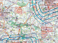
Refer to figure.
The GNSS reads during a VFR flight the co-ordinates 51.83°N 12.19°E. What is the aircraft's position?
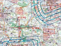
Refer to figure.
1. Firstly, convert the coordinates given as 51.83°N 12.19°E, into Degrees and Minutes form: 51°50'N 12°11.4'E.
2. Locate the closest meridian (12°00') and the closest parallel (52°00'N).
3. From the local meridian passing through 12°11.4'E, draw a vertical line, which crosses all paralles at the same longitude (12°11.4'E).
4. From the local parallel passing through 51°50'N, draw a horizontal line, which crosses all meridians at the same latitude (51°50'N).
5. The intersection between the vertical and horizontal lines is overhead EDAD airport symbol.
Your Notes (not visible to others)
This question has appeared on the real examination, you can find the related countries below.
-
Austro Control3
-
Luxembourg1


 Use Keyboard Shortcuts
