

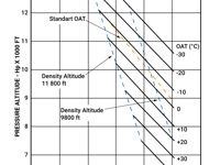
Refer to figure.
What is the maximum helicopter mass to conduct a hover in ground effect at 9000 feet pressure altitude and an outside air temperature of +10°C?
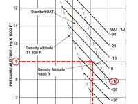
Refer to figure.
This graph is used to determine:
- The maximum mass to Hover In Ground Effect (HIGE) at a given pressure altitude with a given temperature (if entered in the graph with pressure altitude).
- The maximum pressure altitude to Hover In Ground Effect (HIGE) for a given mass at a given temperature (if entered in the graph with mass).
For this question, to determine the maximum helicopter mass to conduct a HIGE, proceed with the following manner:
- Enter with pressure altitude 9000 ft from the left side of the graph.
- Move horizontally to the right until the +10°C temperature line.
- Continue vertically downwards to read the maximum helicopter mass 2410 lbs.
Your Notes (not visible to others)
This question has appeared on the real examination, you can find the related countries below.


 Use Keyboard Shortcuts
Use your keyboard for faster navigation
