

In ground-based weather radar images, what is the typical colour sequence used to represent increasing precipitation intensity, from lightest to heaviest?
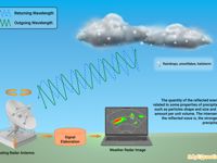
Refer to figure.
Weather radar displays use colour coding to represent the reflectivity of precipitation, which is a measure of the intensity of the radar echo returned from hydrometeors (like raindrops, snow, or hail). The colours provide an intuitive way to assess the severity of weather systems at a glance.
The standard colour sequence for increasing precipitation intensity is:
- Green: Light precipitation (e.g., drizzle or light rain)
- Yellow: Moderate precipitation
- Orange: Heavy precipitation
- Red: Very heavy precipitation, possibly indicating severe thunderstorms or hail
In some systems, additional colours like purple or white are used to denote extremely intense echoes.
- "Blue - green - orange - yellow": Blue is not standard in intensity sequences, it’s often used in satellite imagery (e.g. IR or water vapour), not radar reflectivity.
- "Red - orange - yellow - green": Reverses the correct sequence, red indicates the highest intensity, not the lowest.
- "Green - yellow - blue - red": Blue does not represent intensity.
Your Notes (not visible to others)
This question has appeared on the real examination, you can find the related countries below.
-
Austro Control1
-
Greece1


 Use Keyboard Shortcuts
