

The movement of air flowing together is called…
Refer to figure.
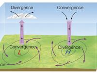
Convergence occurs when winds from different directions meet and come together in a specific region. This process results in the accumulation of air mass in that area. Because more air is being transported into the region than is being moved out, the air pressure increases and the excess air has to go somewhere.
This excess air is forced to rise, leading to vertical movement. As the air rises, it cools and can lead to cloud formation and potentially precipitation.
Divergence is the movement of air flowing apart or away from a common center. When air diverges at the surface, it usually results in sinking air and fair weather conditions. Divergence aloft can enhance rising motion at the surface, contributing to storm development.
Your Notes (not visible to others)
This question has appeared on the real examination, you can find the related countries below.
-
Austro Control2
-
Czech Republic1


