

What phenomenon is caused by cold air downdrafts accompanied by precipitation from a fully developed thunderstorm cloud?
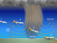
Refer to figure.
As precipitation falls from a fully developed thunderstorm, it partially evaporates during its descent. This process absorbs latent heat from the air, reducing the air temperature. The cooler, denser air then descends, strengthening the downdrafts within the thunderstorm cell. When these cold downdrafts reach the ground, they spread outward along the surface, creating a gust front at the leading edge of the cold air.
Your Notes (not visible to others)
This question has appeared on the real examination, you can find the related countries below.
-
Austro Control1
-
Czech Republic1


 Use Keyboard Shortcuts
Use your keyboard for faster navigation
