

What will happen to the air pressure as the warm front approaches at the surface?
Refer to figure.
As a warm front approaches, the air pressure at the surface gradually decreases. This is due to the advancing warmer, less dense air replacing cooler air and the associated rising motion in the atmosphere ahead of the front. This process leads to a steady drop in pressure until the front passes, after which the pressure may begin to stabilize or slightly rise.
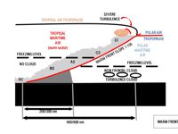
Changes on the passage of a Warm Front
- Temperature and Dew Point: Temperature increases as cold sector air is replaced by warm sector air and dew point increases.
- Visibility: Visibility steadily decreases as the front approaches, then at the front itself expect frontal fog.
- Surface Pressure: Falls as areas of low-pressure approaches (crossing of isobars illustrates reduction in surface pressure) then steadies in the warm sector.
- Cloud and precipitation: Cloud base lowers and cloud thickens with steadily increasing precipitation.
- Wind: Backs initially then veers at the front with a steady increase in speed.
Your Notes (not visible to others)
This question has appeared on the real examination, you can find the related countries below.
-
Austro Control1
-
Ireland1


Use your keyboard for faster navigation
