

In particular across Central Europe, what frontal line divides subtropical air from polar cold air?
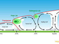
Refer to figure.
The polar front delineates the boundary between polar maritime and tropical maritime air masses, particularly prominent over oceanic regions. This boundary also separates the polar cells from the Ferrel cells. At this zone of low pressure, relatively warm and moist air from the Ferrel Cell interacts with colder, drier air from the Polar Cell.
In the Northern hemisphere: Warm air mass (Tropical airmass) ⇒ South; Cold air mass (Polar air mass) ⇒ North.
The position of the polar front varies with the seasons:
- In winter, it tends to shift to lower latitudes (southward).
- During summer, it moves northward, closer to the poles.
In the Southern Hemisphere, the polar front remains relatively stable throughout the year near 50°S latitude.
Your Notes (not visible to others)
This question has appeared on the real examination, you can find the related countries below.
-
Austro Control3
-
Greece2
-
Romania1


 Use Keyboard Shortcuts
