

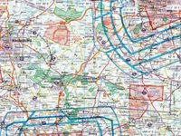
Refer to figure.
What is the distance from EDUZ (Zerbst) (52°N 012.15°E) to EDAZ (Schönhagen) (52.2°N 013.16°E)?

Refer to figure.
For this question, normally a plotter should be required to measure the distance from one point to another. But, the chart scale is not known and, even if it was known, since it is just an excerpt of an aeronautical chart, any scale distortion after printing cannot be guaranteed.
So, the following manner, as the safest one to measure the distance on a chart, is recommended:
- Draw a straight line from the centre of the symbol of EDUZ (Zerbst) airport to the centre of the symbol of EDAZ (Schönhagen) airport.
- Transfer the straight line along a meridian (prefer a "clear" meridian, as free of symbols as possible).
- On this chart, each division along a meridian represents 3'. Since 1′ of latitude is equal to 1 NM, 3′ corresponds to 3 NM.
- Thus, since the line along the meridian is 13', then the distance is: 13' x 3 = 39 NM.
Your Notes (not visible to others)
This question has appeared on the real examination, you can find the related countries below.
-
Austro Control2
-
Germany1


 Use Keyboard Shortcuts
Use your keyboard for faster navigation
