

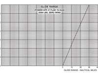
Refer to figure.
Using the Glide Range chart, what is the approximate distance covered during the glide?
Cruising pressure altitude = 9000 ft
Terrain pressure altitude = 3000 ft
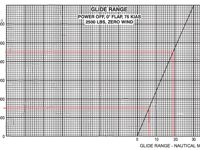
Refer to figure.
When the terrain is not at sea level, the glide distance cannot simply be read at the departure altitude. The correct method is to read two values from the chart independently: the glide range from the cruising altitude to sea level, and the glide range from the terrain altitude to sea level, then subtract the second from the first to obtain the actual horizontal distance covered between those two altitudes.
At 9000 ft, the chart yields approximately 19 NM.
At 3000 ft, the chart yields approximately 6 NM.
The glide distance between the two altitudes is therefore 19 - 6 = 13 NM
Your Notes (not visible to others)
This question has appeared on the real examination, you can find the related countries below.


 Use Keyboard Shortcuts
