

How is an air mass described when it moves to Central Europe via the Russian continent during winter?
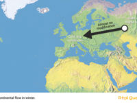
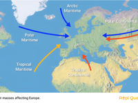
Refer to figures.
The source of Polar Continental air in winter is the very cold, dry air from Russia. As this air mass travels predominantly over land, it brings cold and dry conditions to Europe. It is the coldest air mass affecting mainland Europe, resulting in very cold, clear weather and leading to hard frosts, especially overnight.
The 5 air masses affecting Europe are:
| AIR MASS | SOURCE | CHARACTERISTICS |
| Arctic maritime, mAc | Polar ice cap. Only experienced during NH winter Affects Northern Europe (winter) | unstable, very cold. |
| Polar Maritime, mPc | Northwest area of North Atlantic Affects western Europe Affects Northern Europe | unstable, cold, absolute humidity low, relative humidity high |
| Polar continental, cPc | Siberia (winter only) northern Russia Affects Baltics/Eastern Europe/Baltic coast of Germany (winter) | Stable, very cold and dry. |
| Tropical Maritime, mTw | The Azores anticyclone Affects western Europe Affects southern Europe | Warm, stable, absolute humidity high, RH high. |
| Tropical continental, cTw | N Africa/Middle East/SE Europe (SE Europe – primarily conterminous Balkan Peninsula) Affects eastern Europe | warm, dry, stable. |
Your Notes (not visible to others)
This question has appeared on the real examination, you can find the related countries below.
-
Austro Control1
-
Czech Republic1
-
Greece1
-
United Arab Emirates1


 Use Keyboard Shortcuts
Use your keyboard for faster navigation
