

What kind of weather conditions are usually found in the vicinity of an occlusion?
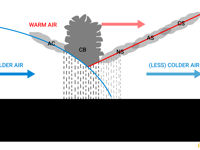
Refer to figure.
An occlusion forms when a faster-moving cold front catches up with a warm front, lifting the warm air off the ground. This usually occurs in the later stages of a mid-latitude depression.
There are two types of occlusions:
- A cold occlusion forms when the air behind the cold front is colder than the air ahead of the warm front.
- A warm occlusion forms when the air behind the cold front is less cold than the air ahead of the warm front.
Cold occlusions are the dominant type, particularly during summer, as the air behind the cold front is colder than the air ahead of the warm front, allowing it to undercut both air masses.
The cloud signature typically includes a deep nimbostratus layer (Ns) with widespread continuous precipitation, and stratus (St) at low levels, along with significant vertical extension where the warm air is lifted aloft. In a cold occlusion (the most common type in winter), the embedded convective elements are often present along the leading edge, producing showers and thunderstorms within the otherwise stratiform mass. In a warm occlusion, the convective activity is generally weaker but still possible.
Then, the typical weather encountered in the area of an occlusion is therefore extensive low and middle level cloud (St or Ns) with high vertical extension, continuous precipitation and embedded showers or thunderstorms.
St or Ns with high vertical extension, embedded showers and thunderstorms → CORRECT. An occlusion combines features of both warm and cold fronts, producing an extensive cloud system dominated by nimbostratus and stratus, with high vertical extension where the warm sector air is lifted aloft. Embedded showers and thunderstorms are common, especially in cold occlusions, due to the residual instability of the lifted warm air. The associated precipitation is widespread and often persistent.
Scattered clouds with isolated showers and thunderstorms → INCORRECT. Scattered clouds with isolated convection are typical of an unstable air mass between fronts (post cold front, for example), or of weak instability under high pressure influence. They do not match the extensive, organised and dense cloud system associated with an occlusion.
Dissipating clouds by widespread descending air → INCORRECT. Dissipating clouds and widespread subsidence are typical of high pressure systems and post frontal clearing, where descending air warms adiabatically and inhibits cloud formation. This is the opposite of what is found in an occlusion, where ascending air dominates and produces extensive cloud cover.
Medium cloud layers and Ci, no precipitation → INCORRECT. This description corresponds to the high altitude precursor of an approaching warm front (Cs and Ci visible long before the front arrives), not to the active occlusion zone itself. By the time the occlusion is overhead, the cloud cover is much more developed and precipitation is widespread.
Your Notes (not visible to others)
This question has appeared on the real examination, you can find the related countries below.


 Use Keyboard Shortcuts
