

Calculate the magnetic track and distance from East London (S33°02’ E027°50’) to George (S34°00’ E022°24’), given a magnetic variation of 25°W.
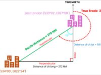
Refer to figure.
Based on the coordinates, it can be seen that the aircraft is travelling in a south-westerly direction. Since both latitude and longitude are changing, the distance must be calculated by considering both components.
1. Calculate the distance of change in latitude
Step 1: Calculate the change in latitude (ch.lat)
- For different hemispheres, we add the two latitudes together.
- For same hemispheres, we subtract the smaller latitude from the larger one.
Since both positions lie in the Southern Hemisphere, we will subtract the latitudes. Therefore,
- Change in latitude = S34°00 - S33°02'
- Change in latitude = 0°58'S*
* We are travelling southwards to a higher latitude, which is why 'South' is indicated.
Step 2: Calculate the distance
A change of 1' of latitude corresponds to a distance of 1 NM. Therefore,
- Distance (NM) = change in latitude (min) x 1 NM
- Distance = 58' x 1 NM
- Distance = 58 NM
2. Calculate the distance of change in longitude
Step 1: Calculate the change in longitude (ch.long)
- For different hemispheres, we add the two longitudes together.
- For same hemispheres, we subtract the smaller longitude from the larger one.
Since both positions lie in the Eastern Hemisphere, we will subtract the longitudes. Therefore,
- Change in longitude = E027°50’ - E022°24’
- Change in longitude = 05°26'W
* We are travelling westwards to a lower longitude, which is why 'West' is indicated.
Step 2: Calculate the distance
The length of 1° of longitude varies with latitude. Therefore, the ‘departure’ formula is used to calculate the east–west distance.
Mean latitude: (Lat 1 + Lat 2) / 2 = (S33°02' + S34°00’) / 2 = S33°31'
- Departure (NM) = ch.long (°) x cos (mean lat) x 60
- Departure = 05°26' x cos (33°31') x 60
- Departure = 272 NM
CALCULATE THE ROUTE DISTANCE
From the figure, a right-angled triangle is formed. Therefore, Pythagoras’ theorem can be used.
- Hyp2 = Base2 + Perp2
- (Route distance)2 = (Distance of ch.lat)2 + (Distance of ch.long)2
- √(Route distance)2 = √[(58 NM)2 + (272 NM)2]
- Route distance = 278 NM
CALCULATE THE TRUE TRACK
Using simple right-angled geometry.
- tan (angle) = Perp / Base
- tan (angle) = Distance of ch.long / Distance of ch.lat
- tan (angle) = 272 NM / 58 NM
- tan (angle) = 5.34
- angle = arctan (5.34)
- angle = 78°
Since the track is measured clockwise from True North. Therefore,
- True Track: 180° + 78° = 258°(T)
CALCULATE THE MAGNETIC TRACK
We can convert the true track to the magnetic track using the given variation. Therefore,
- Using mnemonic “VARIATION WEST → MAGNETIC BEST”
- Magnetic Track: 258°(T) + 25°W = 283°(M)
Therefore, the correct answer is: 283°(M) and 278 NM
Note: 180° is the angle from True North to the base, and the angle between the base and the hypotenuse is 78°.
Your Notes (not visible to others)
This question has appeared on the real examination, you can find the related countries below.


 Use Keyboard Shortcuts
