

The meridians depicted on a Lambert’s Conformal Conic Chart projection appear as…
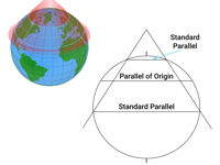
Refer to figure.
The conic projection is derived by placing a cone over the reduced Earth. Unlike the simple conic projection, the Lambert's conformal projection cone slices the reduced Earth to reduce the effect of scale expansion, having two tangential parallels of latitude (called "Standard Parallels), instead of one. At these two parallels, the scale of the chart matches the scale of the Earth, because the standard parallels are the same on the globe as on the cone. Parallel of origin is the latitude exactly midway between the standard parallels, where scale is at its minimum (most contracted) and the cone is parallel to the tangent.
Between the standard parallels, the scale contracts (decreases), i.e. the distance on the reduced Earth is greater than the chart distance. Whilst, outside the standard parallels, the scale expands (increases).
When the cone is unwrapped, or developed, it can be seen that the meridians of longitude are straight lines and converge (slope in) at a constant angle towards the nearer pole.
In a Lambert Conformal Conic projection, great circles, like meridians, are straight lines and the rhumb lines, like parallels of latitude, are curves concave to the pole.
Your Notes (not visible to others)
This question has appeared on the real examination, you can find the related countries below.


 Use Keyboard Shortcuts
