

Which statement is correct?
-
A
On the earth convergence is maximum at the equator.
-
B
On the earth a meridian of longitude is both a great circle and a rhumb line.
-
C
On the earth parallels of latitude are measured up to 180° north and south of the equator.
-
D
On the earth a meridian of longitude is measured up to 90° east and west of Greenwich.
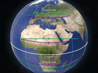
Refer to figure.
Examining each option we get that:
“On the earth convergence is maximum at the equator.” → INCORRECT. Convergency clearly varies with latitude, it will be zero at the Equator where meridians are parallel, and at a maximum at the poles where they converge most.
“On the earth a meridian of longitude is both a great circle and a rhumb line.” → CORRECT. Rhumb lines are lines of constant track, i.e. cut the meridians at the same angle. Great circles are lines, which if extended would form a circumference on the Earth and these tracks mark the shortest distance.
Meridians of longitude are lines that run from south to north between the poles. There is an infinite number, one of which is the Greenwich or Prime meridian. A meridian and its opposite on the other side of the Earth, its anti-meridian, combine to make a circumference around the Earth.
All meridians and the Equator are both rhumb lines and great circles. If you are tracking along a meridian your track would be consant either 000° (northerly), or 180° (southerly), and along the Equator either 090° (easterly), or 270° (westerly), and at the same time the shortest route would be followed.
“On the earth parallels of latitude are measured up to 180° north and south of the equator.” → INCORRECT. Parallels of latitude are lines that run east/west. There is an infinite number of these, one of which is the Equator, half way between the poles and perpendicular to the line joining the poles. They are described by their angle, measured at the centre of the Earth, above or below the Equator. Thus, latitude of the North pole would be 90° N, and the South pole 90° S.
“On the earth a meridian of longitude is measured up to 90° east and west of Greenwich.” → INCORRECT. Meridians of longitude are lines that run from south to north between the poles. There is an infinite number, one of which is the Greenwich or Prime meridian. A meridian and its opposite on the other side of the Earth, its anti-meridian, combine to make a circumference around the Earth. Longitude is the angle measured at the polar axis, between the plane of the Greenwich meridian and the local meridian. Therefore, the minimum longitude is 000° at the Greenwich meridian and the maximum possible latitude is 180° at the Greenwich anti-meridian.
Your Notes (not visible to others)
This question has appeared on the real examination, you can find the related countries below.


 Use Keyboard Shortcuts
