

Overhead HEIDELBERG VOR (HGV, S26°42' E028°18'), en route to Durban International (S29°58' E030°58'). Given a magnetic variation of 25°W, calculate the magnetic heading to steer.
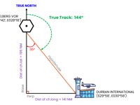
Refer to figure.
Note: This question is similar to 902064.
From the coordinates, the aircraft is traveling in a south-easterly direction. However, since both latitude and longitude are changing, we must calculate the distance of both components.
1. LATITUDE CALCULATION
Step 1: Calculate the change in latitude (ch.lat)
- For same hemispheres, subtract the smaller latitude from the larger one.
- For different hemispheres, add the two latitudes.
Since both positions lie in the Southern Hemisphere, we will subtract the latitudes. Therefore,
- Change in latitude = S29°58' - S26°42'
- Change in latitude = 3°16'S*
* We are travelling towards ‘South’.
Step 2: Calculate the distance
A change of 1° of latitude corresponds to a distance of 60 NM. Therefore,
- Distance (NM) = ch.lat (°) x 60 NM
- Distance = 3°16' x 60 NM
- Distance = 196 NM
2. LONGITUDE CALCULATION
Step 1: Calculate the change in longitude (ch.long)
- For same hemispheres, subtract the smaller longitude from the larger one.
- For different hemispheres, add the two longitudes
Since both positions lie in the Eastern Hemisphere, we will subtract the longitudes. Therefore,
- Change in longitude = E030°58' - E028°18'
- Change in longitude = 02°40'E*
* We are travelling towards ‘East’.
Step 2: Calculate the distance
The length of 1° of longitude varies with latitude. Therefore, the ‘departure’ formula is used to calculate the east–west distance.
Mean latitude: (Lat 1 + Lat 2) /2 = (S26°42' + S29°58') = S28°20'
- Departure (NM) = ch.long (°) x cos (mean lat) x 60
- Departure = 02°40' x cos (28°20') x 60
- Departure = 141 NM
3. MAGNETIC TRACK CALCULATION
From the figure, a right-angled triangle is formed. Therefore,
- tan (angle) = Perpendicular / Base
- tan (angle) = Distance of ch.long / Distance of ch.lat
- tan (angle) = 141 NM / 196 NM
- tan (angle) = 0.72
- angle = arctan (0.72)
- angle = 36°
Since the track is measured clockwise from True North. Therefore,
- True Track: 180° - 36° = 144°
180° is the angle from True North to the base, and the angle between the base and the hypotenuse is 36°.
Now, use the given variation to convert the true track to magnetic track.
- Using the mnemonic “VARIATION WEST → MAGNETIC BEST”
- Magnetic Track: 144°(T) + 25°W = 169°(M)
4. MAGNETIC HEADING CALCULATION
Since no wind information is provided for calculating the heading, we can assume there is no drift. Therefore,
- Magnetic Track = Magnetic Heading → 169°(M)
Therefore, the closest answer is: Magnetic Heading = 170°(M)
Your Notes (not visible to others)
This question has appeared on the real examination, you can find the related countries below.


 Use Keyboard Shortcuts
