

An aeronautical chart which portrays the earth’s features with a very little distortion, is known as…
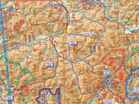
Refer to figure.
An aeronautical chart which portrays the earth’s features with very little distortion is known as “Topographical”.
While orthomorphic and conformal charts focus on preserving angles and shapes, a topographical chart is specifically designed to provide a realistic and detailed representation of physical features (terrain, landmarks, and obstacles) with high accuracy and minimal distortion for navigation.
The most common scales for topographical aeronautical charts vary depending on the detail needed for different phases of flight, ranging from broad planning to high-detail terminal area navigation:
- World Aeronautical Charts (WAC): These use a 1 : 1 000 000 scale. They are designed for moderate-speed aircraft at higher altitudes and provide a broad overview of topography and navigation aids.
- Sectional Aeronautical Charts: The most widely used for VFR (Visual Flight Rules) navigation, these use a 1 : 500 000 scale. They include detailed topographical information like contour lines, shaded relief, and visual checkpoints.
Your Notes (not visible to others)
This question has appeared on the real examination, you can find the related countries below.


 Use Keyboard Shortcuts
